
Nearly 97% of Documented Cannabis Raids Happened Inside or Within Five Miles of a DIA
A Connecticut CannaTimes investigation found that 91.6% of documented cannabis enforcement locations, 96.7% of search-warrant raids, and 92.7% of enforcement actions involving arrests occurred inside or within five miles of areas Connecticut designated as disproportionately harmed by the drug war.
Part of Cannabis Enforcement and the DIA Map · Cannabis Licensing and Social Equity
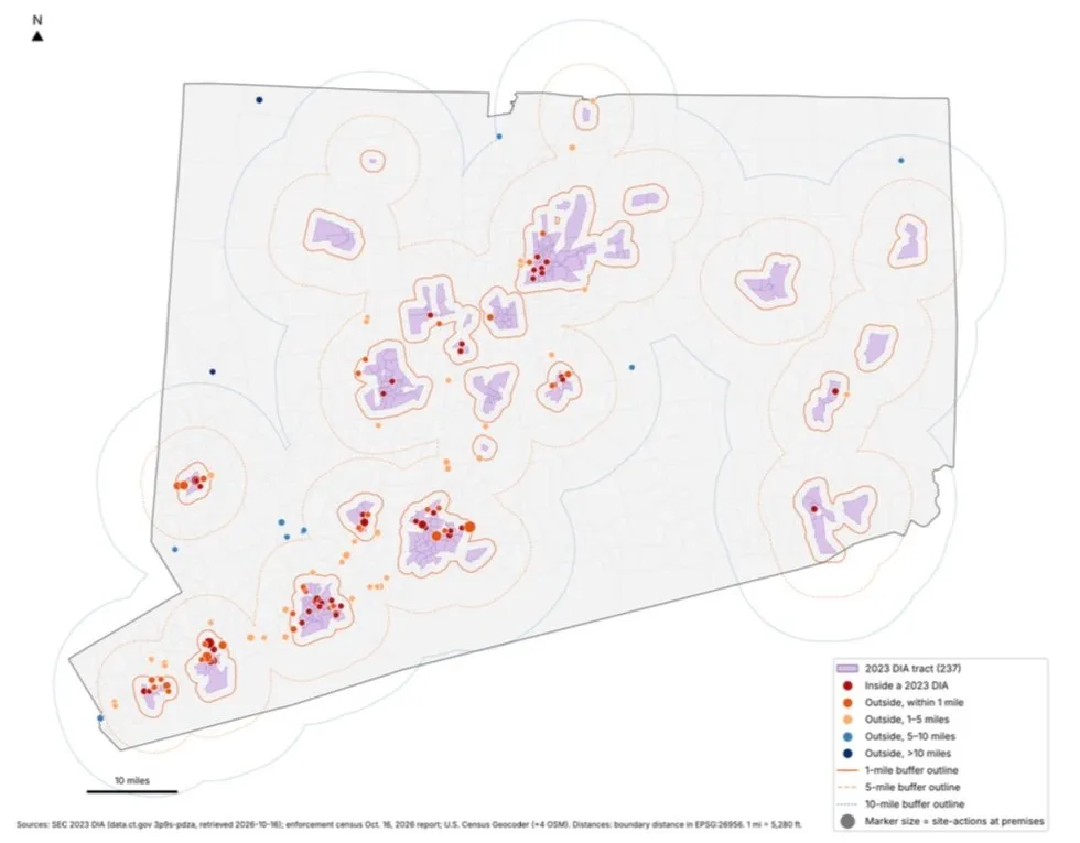


Connecticut legalized recreational cannabis in 2021. It also established a social equity program intended to help communities harmed by decades of drug prohibition.
Now, a geographic analysis of publicly documented cannabis-related enforcement between January 2023 and October 16, 2026 reveals just how closely the state’s ongoing enforcement activity overlaps with those same communities.
Of 155 enforcement locations that could be geographically classified, 142, or 91.6%, were located directly inside or within five miles of a Disproportionately Impacted Area.
The numbers become even more striking when examining the types of enforcement:
- 96.7% of documented search-warrant raids, 117 of 121 geographically classified actions, occurred inside or within five miles of those areas.
- 92.7% of enforcement actions involving reported arrests, 114 of 123, occurred within that same distance.
- 100% of geographically classified felony-level charge records, 23 of 23, were associated with locations inside or within five miles of a DIA. Those records represent 14 separate felony-related enforcement incidents, not 23 separate raids.
Expand the distance to ten miles, and 98.7% of all classified enforcement locations fall within that range. Only two of the 155 locations were more than ten miles from any DIA.
These are publicly documented enforcement actions, not a complete statewide accounting. The investigation compiled information from police announcements, government records, court filings, agency enforcement releases and news reports. Complete statewide inspection and enforcement records were not available.
The geographic findings raise questions about how Connecticut’s continuing cannabis enforcement intersects with its stated commitment to repairing the damage caused by prohibition.
What Is a Disproportionately Impacted Area?
A Disproportionately Impacted Area, or DIA, is a Connecticut census tract officially designated as a community disproportionately harmed by historical drug enforcement and economic disadvantage.
These aren’t arbitrary neighborhoods drawn on a map.
Under Connecticut law, the Social Equity Council identifies DIAs using historical drug-conviction rates and poverty data. The 2023 designation process ranked qualifying census tracts and selected them until their combined population approached 25% of Connecticut’s population.
The resulting map contains 237 designated census tracts, home to approximately 899,000 people.
These designations matter because they form part of the foundation of Connecticut’s cannabis social equity program. Residency in a DIA can help determine eligibility for certain cannabis business opportunities, while state law directs attention and resources toward communities historically damaged by drug prohibition.
In other words, Connecticut has formally identified these areas as communities deserving targeted economic repair.
That makes the geographic relationship between those areas and present-day cannabis enforcement worth examining.
The Five-Mile Finding
The original Connecticut CannaTimes enforcement investigation identified 253 cannabis-related enforcement site-actions at 163 distinct premises across 44 municipalities.
Of those 163 locations, 155 had sufficiently resolved geographic information to calculate their proximity to the official 2023 DIA boundaries. Eight could not be classified and were excluded from the distance percentages.
The locations did not fall evenly across the state.
Sixty-two premises, or 40%, were directly inside a DIA.
Another 41 premises, or 26.5%, were outside a DIA but less than one mile from its boundary.
That means 66.5% of all classified enforcement premises were inside or within just one mile of a DIA.
Another 39 premises, representing 25.2%, were between one and five miles away.
Together, that brings the five-mile total to 142 of 155 locations, or 91.6%.
Eleven additional locations, or 7.1%, were between five and ten miles away.
Just two locations, or 1.3%, were more than ten miles from any designated area.
Put another way, only 13 of the 155 geographically classified enforcement locations, or 8.4%, were more than five miles from the nearest DIA.
These distances were calculated from the physical enforcement premises to the nearest DIA boundary, not to the center of a municipality or census tract.
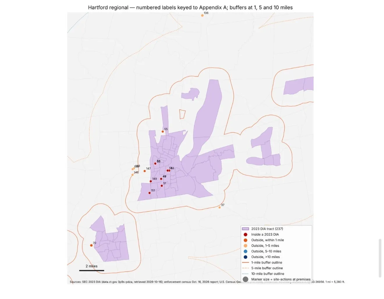
Hartford region. Numbered markers are keyed to Appendix A of the underlying report; buffers at 1, 5 and 10 miles. Hartford is known to be underrepresented in the available public inventory.
Search Warrants and Arrests Were Even More Concentrated
The proximity becomes more pronounced when distinguishing routine enforcement visits from more intrusive police actions.
Of 121 geographically classified cannabis-related search-warrant raid actions, 57 occurred directly inside DIAs. Another 35 occurred within one mile, and 25 took place between one and five miles away.
That puts 117 of 121 documented search-warrant raids, or 96.7%, inside or within five miles of a DIA.
Only three raids occurred between five and ten miles away. Just one occurred beyond ten miles.
The arrest figures follow a similar pattern.
Of 123 geographically classified site-actions involving reported arrests, 61 occurred inside DIAs, 34 occurred within one mile, and 19 took place between one and five miles away.
That means 114 of those 123 arrest-related actions, or 92.7%, fell within the five-mile range.
Seven occurred between five and ten miles away, and two occurred beyond ten miles.
The investigation also identified 23 geographically classified felony-level charge records. Fifteen were associated with premises inside DIAs, four with premises within one mile, and four with premises between one and five miles away.
None of the geographically classified felony-level charge records fell beyond five miles.
Importantly, seven of the felony records came from a single Ansonia investigation involving an alleged cannabis and psychedelic mushroom market at the Subalpi Club. That one investigation accounts for a substantial portion of the felony total.
These figures describe where enforcement occurred, not where defendants lived or whether they were eligible for Connecticut’s social equity programs.
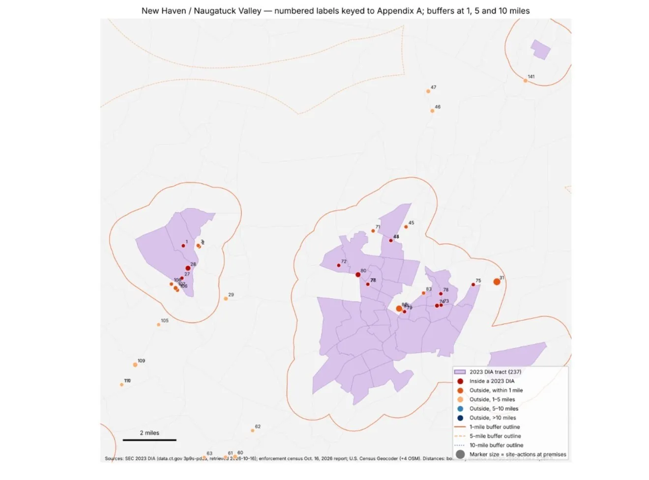
New Haven and the Naugatuck Valley. The Ansonia cluster at left includes the Subalpi Club investigation that accounts for seven of the 23 felony-level charge records.
What Happened Beyond Five Miles?
The 13 enforcement premises more than five miles from a DIA are important because they show what the statewide picture looks like outside the immediate geographic concentration.
Five were in Monroe. Those included A&W Smoke Shop locations, FM One Stop, Stop & Vape Convenience, and Area 51 Smoke Shop. The documented actions included inspections, an alleged cannabis sales investigation involving a search warrant, seizures, and reported criminal charges.
Two were in Greenwich: Byram Smoke Shop and State Line Stationary, also identified as Stateline Smoke Shop. The records included a compliance inspection and a search-warrant investigation involving alleged illegal THC product sales.
Granby’s J&J Vape and Variety was approximately 9.8 miles from the nearest DIA boundary. A May 2025 inspection involving Granby police and state agencies reportedly resulted in seizure of cannabis products and an arrest.
In Ridgefield, Village Smoke Shop was approximately 6.3 miles from a DIA. A 2025 inspection involving local police and DCP resulted in two reported arrests involving cannabis-related allegations and other products.
Putnam’s MJ Smoke Shop, approximately 7.2 miles from a DIA, was the subject of a September 2026 search involving local police and DCP’s Cannabis Control Division. Police reported finding cannabis products and other merchandise.
East Hampton’s Hampton Tobacco & Vape, approximately 7.1 miles away, was the subject of a January 2026 enforcement action in which authorities reported removing cannabis products, including vapes, edibles, flower and extracts.
Only two locations fell beyond ten miles.
M&D Smoke and Vape Shop in New Milford was approximately 11.4 miles from the nearest DIA. Authorities reported a 2024 enforcement action involving illegal cannabis and vaping products and a closure order.
Smoker’s Choice in North Canaan was approximately 14.2 miles from the nearest DIA. It was the subject of a January 2026 search-warrant investigation and a subsequent June inspection. The records describe alleged unlawful cannabis product sales, seizures, and arrests, including the owner and a cashier.
These more distant cases demonstrate that cannabis-related enforcement was not confined to DIA communities. However, in the publicly documented inventory, the overwhelming majority of locations and search warrants remained within five miles of them.
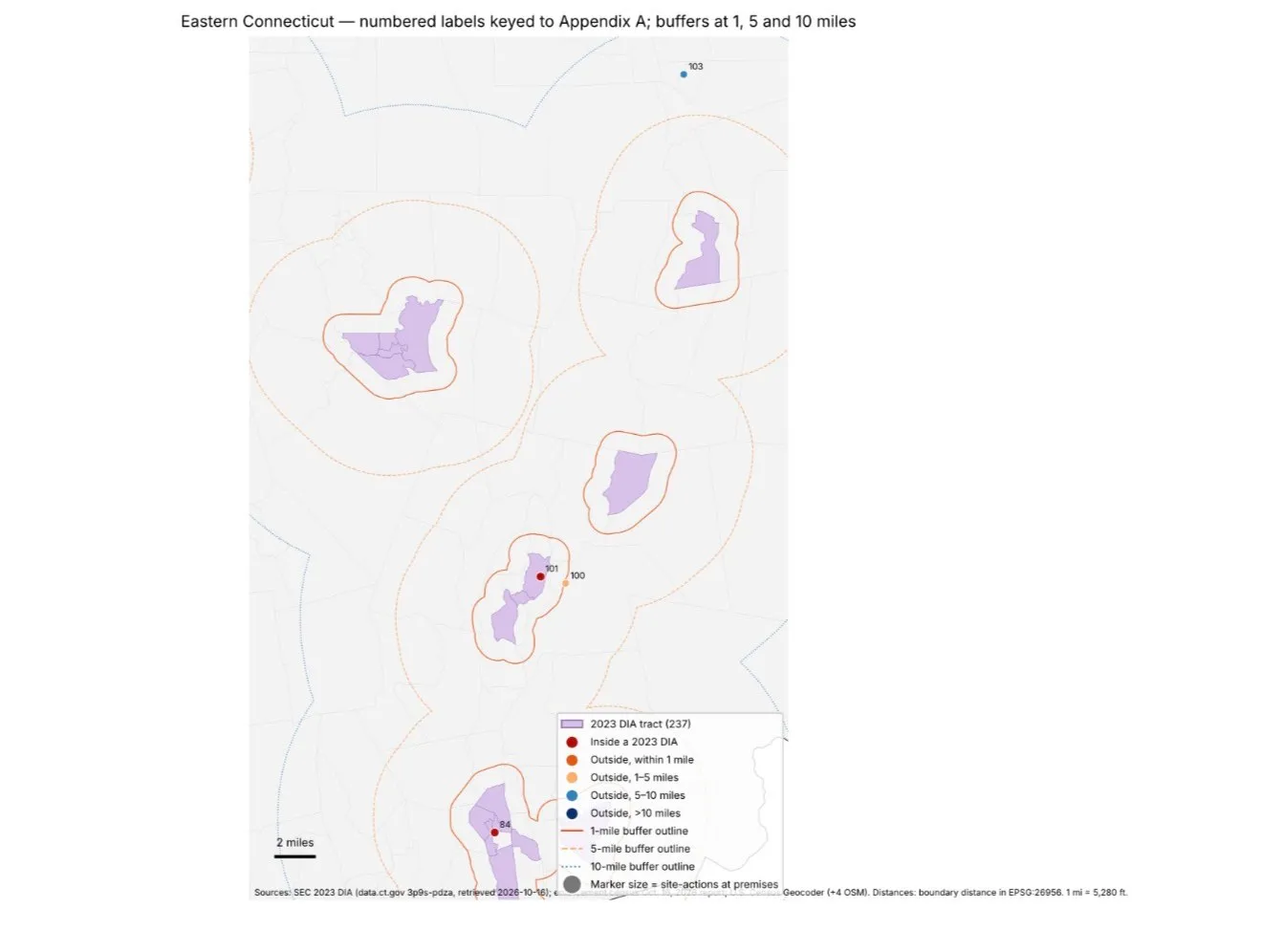
Eastern Connecticut. Enforcement here was sparse; Putnam’s MJ Smoke Shop (103) sits more than five miles from the nearest DIA.
Some of Connecticut’s Most Frequently Raided Businesses Were Just Outside DIA Boundaries
The one-mile analysis uncovered another significant detail.
Several repeatedly targeted businesses were technically outside a DIA, sometimes by only a few hundred feet.
At 108 Connecticut Avenue in Norwalk, a location operating under several smoke-shop and convenience-store names was approximately 286 feet outside a DIA boundary.
The investigation documented seven search warrants at that address and nine reported arrests associated with its enforcement history.
In New Haven, Anesthesia Convenience & Smoke at 968 Chapel Street was approximately 704 feet outside a DIA. The location was associated with seven recorded enforcement and civil-outcome actions.
In Danbury, Star Rose Vape & Smoke was approximately 0.41 miles outside a DIA and had five documented actions. CT Smoke House, approximately 0.94 miles outside, had four.
In Bridgeport, two businesses along Main Street were geocoded approximately 21 feet from a DIA boundary, effectively placing them on the dividing line between census tracts.
These examples show why simply describing a premises as being outside a DIA can conceal how close it is to a designated community.
They also illustrate a limitation. Census tract boundaries frequently follow streets, and geocoded addresses near those boundaries can fall on either side depending on positional accuracy. The one-mile cumulative findings are more resistant to that uncertainty than strict inside-versus-outside classifications.
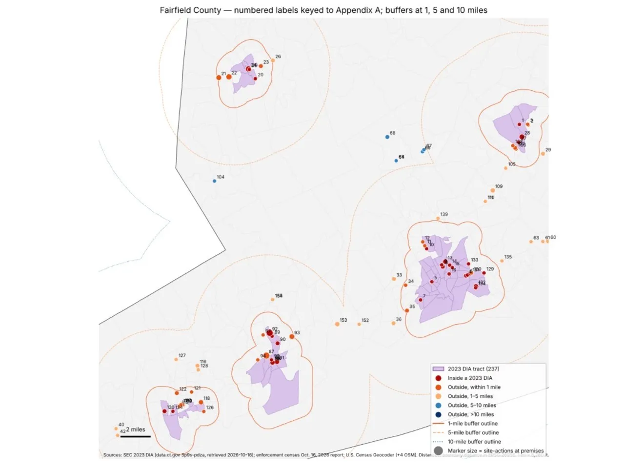
Fairfield County. The Norwalk, Bridgeport, Stamford and Danbury clusters include the repeatedly raided premises that sit a few hundred feet outside a DIA line.
Is Enforcement Concentrated There Because That’s Where the Smoke Shops Are?
This is the most important question raised by the data, and the investigation provides a partial answer.
Connecticut’s registered smoke and vape businesses are themselves geographically concentrated near DIAs.
Of 622 DCP-registered electronic-cigarette dealer premises with smoke- or vape-related names that were active during the study period, approximately 87.6% were inside or within five miles of a DIA.
Among the targeted smoke/vape-shop premises in the enforcement inventory, the comparable figure was 91.5%.
That difference is modest.
But look within one mile.
Approximately 55.9% of registered smoke/vape-named businesses were directly inside or within one mile of a DIA.
The comparable figure for targeted smoke shops was 67.8%.
For search-warrant raids across all venue types, it was 76%.
For enforcement actions involving arrests, it was 77.2%.
The report also calculated the proportion of registered smoke/vape-named premises targeted in each geographic band.
- Inside DIAs, the documented targeted-premises count amounted to 24.9% of registered smoke/vape-named premises.
- Within the first mile outside DIAs, it was 20.6%.
- Between one and five miles, it fell to 14.2%.
- Between five and ten miles, it was 14.3%.
- Beyond ten miles, it was 9.5%.
These are descriptive comparisons, not definitive probabilities that a business would be targeted. Some enforcement locations had no matching DCP registration, and the available records do not establish every business’s operating period or every enforcement encounter.
Still, the pattern raises a question that the available public records cannot fully answer: Why does the documented concentration of raids and arrest-related enforcement rise more sharply near DIAs than the concentration of registered smoke shops alone?
Possible explanations include the density of commercial corridors, complaints, repeated violations, local police resources, enforcement priorities, and differences in which agencies publicize their actions.
The current data does not establish discriminatory intent or prove that any agency deliberately targeted a DIA because of its social equity designation.
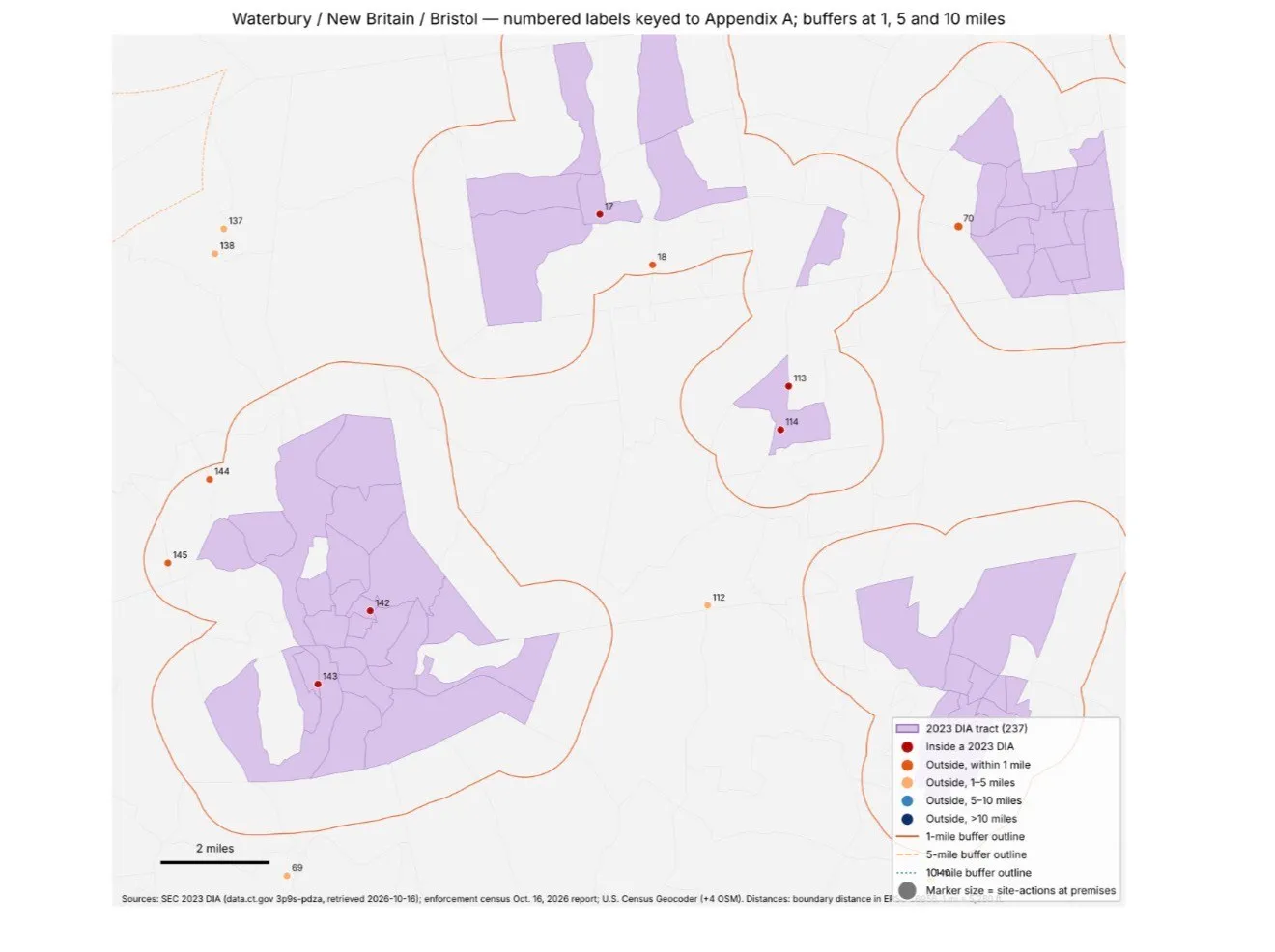
Waterbury, New Britain and Bristol. Most documented premises here sit inside a DIA tract or on its one-mile buffer.
Connecticut’s Social Equity Council Has a Seat on the Enforcement Policy Board
There is another reason the findings deserve public scrutiny.
Connecticut’s Social Equity Council is charged with promoting participation in the legal cannabis industry by communities disproportionately harmed by cannabis prohibition and enforcement.
At the same time, Public Act 25-166 established a State-Wide Cannabis and Hemp Enforcement Policy Board tasked with identifying enforcement needs and opportunities concerning illegal cannabis and intoxicating hemp sales.
The Social Equity Council’s executive director, or a designee, holds a statutory seat on that board.
The Council’s membership was briefly removed through one 2026 legislative act before being restored through subsequent legislation effective October 1, 2026.
The original CannaTimes research found no recorded Council vote endorsing the 2025 enforcement provisions and no documented enforcement action attributable to the policy board itself.
The existence of the Council’s seat does not establish that the Council directed any of these raids.
But it raises a legitimate question about how the state coordinates its enforcement priorities with its commitments to communities harmed by prohibition.
The investigation also identified gaps in the public record, including the absence of a located DCP annual report required under the new Cannabis Control Division statute and a complete publicly available enforcement inspection ledger.
Without those records, the public cannot independently determine the full statewide enforcement picture or evaluate how the newer enforcement framework is operating.
The Question Connecticut Needs to Answer
Connecticut legalized cannabis, established a Social Equity Council, designated communities harmed by drug prohibition, and created pathways intended to help repair those harms.
At the same time, cannabis-related criminal and civil enforcement continues across the state.
This investigation identifies 253 publicly documented cannabis-related enforcement site-actions over nearly four years. Of the 245 that could be geographically classified, 229, or 93.5%, occurred directly inside or within five miles of a DIA.
Among search-warrant raids, that figure reached 96.7%.
Among arrest-related site-actions, it reached 92.7%.
And among the felony-level charge records with resolved geography, it reached 100%.
The geographic concentration alone does not establish wrongdoing. It does not mean residents of DIAs were the people arrested. It does not prove enforcement was motivated by race, poverty, or social equity status. And a five-mile radius is a geographic research measurement, not an expansion of Connecticut’s legal DIA boundaries.
These are publicly documented enforcement actions, not a complete statewide accounting. Hartford is known to be underrepresented in the available inventory, and DCP’s complete inspection records remain unavailable for comparison.
Those limitations matter.
But so do the numbers.
Only 13 of the 155 classified enforcement locations were more than five miles from a DIA. Only two were more than ten miles away.
Connecticut has already acknowledged, through its cannabis equity laws, that certain communities suffered disproportionate harm under drug prohibition.
The next question is whether today’s cannabis enforcement system is being measured against that history, and whether the agencies responsible for enforcement and social equity can publicly account for what is happening in and around those communities.
Legalization was supposed to mark a new chapter in Connecticut’s relationship with cannabis. The public deserves enough information to determine what has changed, what has continued, and who is bearing the consequences.
Research basis: Connecticut CannaTimes, “Cannabis Enforcement and the DIA Map,” October 16, 2026, and “Cannabis Enforcement Proximity to Disproportionately Impacted Areas,” October 17, 2026. The analysis uses publicly reported enforcement activity, official DIA geography, premises records and registered-shop comparisons. Distances are boundary distances computed in EPSG:26956; 1 mile = 5,280 feet.
Sources
More in Cannabis Enforcement and the DIA Map
The full investigation- Crisp Cannabis President Charged With Animal Cruelty After Dogs Left in Locked Car, Police SaySeptember 17, 2026 · Courts
- Would Fentanyl Even Survive a Burning Joint?June 10, 2026 · Enforcement
- Bridgeport Police Say Cannabis Tested Positive for Fentanyl. The Charges Raise Questions.June 10, 2026 · Enforcement
Related Stories

Smith v. Lamont Is Not Over: The Judge Ruled on Neither Side of the Constitutional Question
A federal judge dismissed the original complaint in Smith v. Lamont without prejudice. An amended complaint is on file, a Massachusetts grower is asking to join, and no court has ruled on whether Connecticut’s social equity licensing restrictions are constitutional.
The Pequot Compact Shows the Licensing Barriers Were Always Manufactured
For years, the state treated cannabis licenses like golden tickets. Limited licenses. Lottery windows. Application fees. Social Equity Council reviews. DCP bottlenecks. Ownership audits. Residency tests. Income tests. Backer scrutiny. Management agreement restrictions. Years of delay.
SEC Moves to Cut the Social Equity Exit Rule From Seven Years to Three Through DCP E-Regulations
Connecticut lawmakers warned this would happen. They warned who it would benefit. They warned it would gut social equity. And now, despite those warnings being made on the record, the Social Equity Council has formally proposed the very change legislators said would invite buyouts and push equity owners out.
Federal Probe Ties Cannabis Consulting, Nonprofit Grants and Political Power
A sweeping federal grand jury investigation into state-funded nonprofits and political favoritism in Connecticut is exposing deeper links to cannabis licensing, questionable grants, and influence-peddling—centered around Senator Douglas McCrory (D-Bloomfield) and his longtime associate, Sonserae “Cicero” Hamlin, operator of the startup nonprofit SHEBA (Society for Human Engagem